The message was clear. We needed to demonstrate progress and outcomes to sustain the political support we had achieved through the data roadmaps for sustainable development process. It was at the UN General Assembly (UNGA) in 2017 that the Global Partnership for Sustainable Development Data met with several of our country focal points to discuss progress, challenges, and key priorities regarding data for the Sustainable Development Goals (SDGs). These discussions were supported by NASA and the Group on Earth Observations (GEO), whom we had been working closely with over the previous year to address a consistent challenge across our roadmap countries – building the capacity to access and use geospatial and earth observation (EO) data.
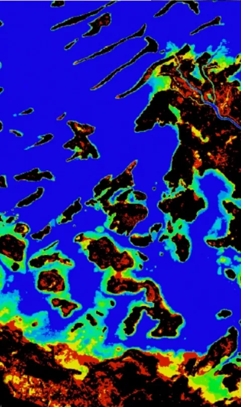
With NASA and GEO, along with other contributing partners including the European Space Agency and the University of Maryland, we initiated a focused program, starting with the National Administrative Department of Statistics (DANE) in Colombia, identifying specific gaps and challenges on SDG indicators that EO data could support. DANE is a global leader on data innovations and data integrations in the context of the data revolution for sustainable development and had already identified EO data’s value in supporting monitoring of the SDGs. Interestingly, through the course of this work, we also learned that the Institute of Hydrology, Meteorology and Environmental Studies (IDEAM) had implemented a data cube, with the help of the Committee on Earth Observation Satellites (CEOS). The CEOS data cube is a data processing platform for earth science data, with a focus on remote-sensing data (e.g. satellite data). The data is put into an analytically ready format where satellite images of various resolutions can be “stacked” across a time-series such that algorithms can be easily applied and trends understood. Much of the data (e.g. Landsat or Sentinel) a data cube utilizes is already freely available through the US and European space programs, but one of the data cube’s key added values is that it cuts about 80% of the time a researcher expends on preparing images for analysis.
Rewind back to UNGA in 2017: our country partners discussed the potential challenges with the upcoming 2020 census round, particularly around agriculture and its impact on food security. Kenya had a very simple yet complex challenge. The Minister of Agriculture needs to better understand the distribution of agricultural land in Kenya – how much is there, what are the crops, and how healthy are the crops. For national-level planning purposes, it was identified that freely available EO data could support this challenge and perhaps the data cube was one potential solution (noting that other solutions also exist that are solving for these problems).
At the GEO Plenary in 2017, we continued our discussions with CEOS on the potential of a data cube as a solution. It quickly became apparent that there was some real synergy here – the objectives of this CEOS program aligned well with country-level demand, with several use cases already identified. It was there that we agreed to develop the Africa Regional Data Cube (ARDC) for the five core countries the Global Partnership is working with on the data roadmap process – Senegal, Ghana, Sierra Leone, Kenya, and Tanzania. Kenya was a catalyst for pushing this solution forward in alignment with the growing Intergovernmental Network on Open Data for Agriculture and Nutrition, which would add the needed policy dimension these data could support.
We had to think through many additional factors – who would be the institutional host? How would we address capacity building? Would this be deployed on premise or in the cloud? What would the sustainable business model look like? And so on. We partnered with Amazon Web Services, who generously provided a 2-year grant for hosting the data cube, and we leveraged our partnership with Strathmore University to become the institutional host of the ARDC. The CEOS team has been working feverishly on the ARDC, which we soft launched today at the Data for Development Festival in Bristol, UK. We’re also developing a training workshop to be held in Kenya in May, to bring together technical and institutional representatives across institutions from the five countries.
This partnership demonstrates the core value of the Global Partnership in its brokering ability and the value partner organizations offer. It starts with understanding the problem and its prevalence. We then connect that demand with supply by building relationships with key in-country stakeholders and partner organizations, and define a solution that specifically addresses the challenge in support of multi-stakeholder, data ecosystem approaches. I cannot say enough about CEOS, NASA, GEO, AWS, Strathmore University, and our five country partners, in particular Kenya, for taking on a leadership role. A huge thanks to all these organizations. I can’t wait to see the outcome of this!
Press Release: New satellite technology tool transforms ability to manage food security in five African countries
Photo: Data Cube Application Example. A 17-year data cube time series was used to detect the existence of water in Lake Chad in Cameroon, Africa. The results show the percent of time that each 30-meter pixel has observed water over the time period.


